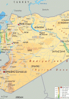
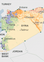
Syria Map
Syria Map, officially known as the Syrian Arab Republic, is a country in Western Asia, bordering Lebanon and the Mediterranean Sea to the west, Turkey to the north, Iraq to the east, Jordan to the south, and Israel to the southwest.
Syria Map
you are free to use this map for educational purposes, please refer to the Nations Online Project.
Recommend this page: If you would like to recommend this Syria map page to a friend, or if you just want to send yourself a reminder, here is the easy way to do it. Simply fill in the e-mail address and name of the people you wish to tell about wpmap.org, your name and e-mail address (so they can reply to you with gracious thanks), and click the recommend button. The URL of this site will be included automatically. You may also enter an additional message that will be also included in the e-mail.